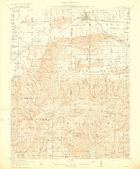
1916 Map of Equality
USGS Topo · Published 1916About this map
Equality serves as the focal point for this Southern Illinois landscape, situated at a bend in the Saline River where the Louisville and Nashville railroad cuts through the terrain. The map reveals an early industrial footprint defined by salt and mineral resources, including the Illinois Furnace and scattered mining operations like Pierce Mines and Lees Mine. Settlement patterns follow the elevation of the Wildcat Hills and the winding course of Eagle Creek, with a dense network of country schools such as Kedron School and Jones School serving the agrarian and mining families of the era.
Find a feature on this map
111 named features on this map. Tap any name to fly to it.
Don’t see what you’re looking for? This feature index may not catch every label — zoom into the map to look around manually.
Map Details
Editions of this 1916 Equality Map
4 editions found
Other maps of this area

1905 · Eldorado
USGS Topo · 1:62,500

1905 · New Haven
USGS Topo · 1:62,500

1906 · New Haven
USGS Topo · 1:62,500

1906 · Eldorado
USGS Topo · 1:62,500

1908 · Galatia
USGS Topo · 1:62,500

1916 · Shawneetown
USGS Topo · 1:62,500

1916 · Fords Ferry
USGS Topo · 1:62,500

1916 · Golconda
USGS Topo · 1:62,500

1916 · Equality
USGS Topo · 1:62,500

1917 · Brownfield
USGS Topo · 1:62,500