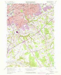
1957 Map of Erie South
USGS Topo · Published 1976About this map
Erie and its southern townships reveal a landscape undergoing significant post-war expansion, with extensive purple-tinted urban updates layered over a mid-century base. The city’s core is dense with educational and religious institutions, including Villa Maria College and Mercyhurst College, while heavy industry and transit hubs like Dock Junction define the northwestern lakefront. The rail infrastructure is prominent, featuring lines of the Penn Central, Norfolk and Western, and Bessemer and Lake Erie that intersect the grid.
Find a feature on this map
97 named features on this map. Tap any name to fly to it.
Don’t see what you’re looking for? This feature index may not catch every label — zoom into the map to look around manually.
Map Details
Editions of this 1957 Erie South Map
4 editions found

Other maps of this area

1899 · Erie
USGS Topo · 1:62,500

1900 · Erie
USGS Topo · 1:62,500

1913 · North East
USGS Topo · 1:62,500

1915 · North East
USGS Topo · 1:62,500

1923 · Cambridge Springs
USGS Topo · 1:62,500

1925 · Cambridge Springs
USGS Topo · 1:62,500

1929 · Union City
USGS Topo · 1:62,500

1932 · Union City
USGS Topo · 1:62,500

1943 · North East
USGS Topo · 1:62,500

1943 · Cambridge Springs
USGS Topo · 1:62,500