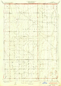
1934 Map of Esperanza School
USGS Topo · Published 1934About this map
Antelope Valley defines the landscape of this 1930s survey, showing a strictly gridded agricultural and infrastructure network along the border of Kern and Los Angeles Counties. The map reveals a dispersed rural community organized around irrigation and early electrical development, characterized by numerous wells and a prominent Transmission Line feeding into a local Sub-Station. Social life in this portion of the high desert centered on small neighborhood institutions, including the Esperanza Sch and Rogers Sch. Notably, the presence of the Japanese Ch indicates the specific cultural and demographic footprint of Japanese-American farmers in the region during the interwar period. The terrain is marked by a vast system of named avenues and Neenach Road, reflecting the formalization of local transport routes across the arid floor.
Find a feature on this map
10 named features on this map. Tap any name to fly to it.
Don’t see what you’re looking for? This feature index may not catch every label — zoom into the map to look around manually.
Map Details
Editions of this 1934 Esperanza School Map
3 editions found

Other maps of this area

1915 · Elizabeth Lake
USGS Topo · 1:125,000

1917 · Elizabeth Lake
USGS Topo · 1:125,000

1930 · Oban
USGS Topo · 1:24,000

1930 · Lancaster
USGS Topo · 1:24,000

1931 · Little Buttes
USGS Topo · 1:24,000

1931 · Del Sur
USGS Topo · 1:24,000

1931 · Esperanza School
USGS Topo · 1:24,000

1932 · Lake
USGS Topo · 1:24,000

1933 · Lancaster
USGS Topo · 1:24,000

1933 · Oban
USGS Topo · 1:24,000