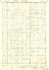
1934 Map of Esperanza School
USGS Topo · Published 1934About this map
The Antelope Valley floor is mapped here in meticulous detail during the early 1930s, revealing a landscape defined by an emerging grid of dirt and gravel roads. Settlers in this high desert region relied heavily on subterranean water, evidenced by the numerous instances of Well scattered across the township lines. The social fabric of this rural community is anchored by local landmarks like the Esperanza Sch and Rogers Sch, alongside the notable Japanese Ch, which reflects the diverse agricultural heritage of the area.
Find a feature on this map
26 named features on this map. Tap any name to fly to it.
Don’t see what you’re looking for? This feature index may not catch every label — zoom into the map to look around manually.
Map Details
Editions of this 1934 Esperanza School Map
3 editions found

Other maps of this area

1915 · Elizabeth Lake
USGS Topo · 1:125,000

1917 · Elizabeth Lake
USGS Topo · 1:125,000

1930 · Oban
USGS Topo · 1:24,000

1930 · Lancaster
USGS Topo · 1:24,000

1931 · Little Buttes
USGS Topo · 1:24,000

1931 · Del Sur
USGS Topo · 1:24,000

1931 · Esperanza School
USGS Topo · 1:24,000

1932 · Lake
USGS Topo · 1:24,000

1933 · Lancaster
USGS Topo · 1:24,000

1933 · Oban
USGS Topo · 1:24,000