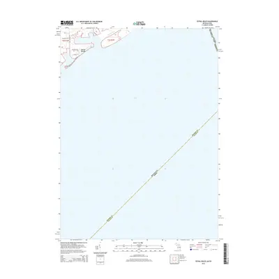
2014 Map of Estral Beach
USGS Topo · Published 2014About this map
Estral Beach occupies a narrow stretch of the western shoreline where the Michigan coast meets the expanse of Lake Erie. This coastal settlement is defined by its compact grid of streets, including Center St and Lakeview Blvd, positioned at the edge of the water. The surrounding landscape is dominated by the marshy drainage of Mouillee Creek and Langton Drain, highlighting the delicate hydrological balance of this low-lying lakeside environment. The map provides a clear view of the international and state boundaries that converge in the open water, including the lines separating Michigan and Canada as well as Michigan and Ohio. Access to this small community is maintained via local routes like Masserant Rd and Port Sunlight Rd, which connect the shore to the interior of Monroe County.
Find a feature on this map
12 named features on this map. Tap any name to fly to it.
Don’t see what you’re looking for? This feature index may not catch every label — zoom into the map to look around manually.
Map Details
Editions of this 2014 Estral Beach Map
This is the sole edition of this map. No revisions or reprints were ever made.
Other maps of this area

1906 · Wyandotte
USGS Topo · 1:62,500

1906 · Romulus
USGS Topo · 1:62,500

1912 · Wyandotte
USGS Topo · 1:62,500

1912 · Monroe
USGS Topo · 1:62,500

1914 · Monroe
USGS Topo · 1:62,500

1928 · Romulus
USGS Topo · 1:62,500

1929 · Wyandotte
USGS Topo · 1:62,500

1936 · Rockwood
USGS Topo · 1:31,680

1936 · Stony Point
USGS Topo · 1:31,680
1936 · Flat Rock
USGS Topo · 1:31,680
Featured Places
- Frenchtown Charter Township, MI
- Berlin Charter Township, MI
- Estral Beach, Berlin Charter Township
- Lucas County, OH