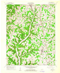
1961 Map of Eubank
USGS Topo · Published 1962About this map
Eubank and Waynesburg anchor this topographical survey, which traces the complex boundary lines between Lincoln, Pulaski, Casey, and Rockcastle counties in the early 1960s. The landscape is defined by the Southern railroad corridor running north-south through the dissected plateau. Along the ridges and hollows, a network of country churches like Locust Grove Ch and Phillips Chapel served small farming communities.
Find a feature on this map
44 named features on this map. Tap any name to fly to it.
Don’t see what you’re looking for? This feature index may not catch every label — zoom into the map to look around manually.
Map Details
Editions of this 1961 Eubank Map
2 editions found
Other maps of this area

1935 · Somerset
USGS Topo · 1:62,500

1952 · Halls Gap
USGS Topo · 1:24,000

1952 · Eubank
USGS Topo · 1:24,000

1952 · Crab Orchard
USGS Topo · 1:24,000

1952 · Hustonville
USGS Topo · 1:24,000

1952 · Yosemite
USGS Topo · 1:24,000

1952 · Woodstock
USGS Topo · 1:24,000

1953 · Mintonville
USGS Topo · 1:24,000
1954 · Bobtown
USGS Topo · 1:24,000

1954 · Science Hill
USGS Topo · 1:24,000