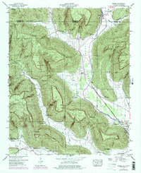
1947 Map of Eureka
USGS Topo · Published 1977About this map
The Tennessee Alabama state line bisects this 1947 landscape, where the ridges of Little Coon Mountain and the water of Guntersville Lake define the terrain. The Louisville and Nashville railroad runs through the Crow Creek valley, connecting small communities like Anderson and Gonce. A high density of family burial grounds, including Jacoway Cem, McCrary Cem, and Allison Cem, points to the deep generational ties of the families farming these valleys. The map reveals a rural economy structured around crossroads like Biscoe Store and the John Sumach Reservation, while the New Hope Church and Helton Memorial Church serve as centers of community life. This survey, photorevised in the 1970s, preserves the early 20th-century road network and the distinct agricultural pockets found in Little Coon Valley and Hicks Cove.
Find a feature on this map
54 named features on this map. Tap any name to fly to it.
Don’t see what you’re looking for? This feature index may not catch every label — zoom into the map to look around manually.
Map Details
Editions of this 1947 Eureka Map
4 editions found
Other maps of this area

1886 · Stevenson
USGS Topo · 1:125,000

1888 · Scottsboro
USGS Topo · 1:125,000

1892 · Scottsboro
USGS Topo · 1:125,000

1892 · Stevenson
USGS Topo · 1:125,000

1895 · Stevenson
USGS Topo · 1:125,000

1895 · Sewanee
USGS Topo · 1:125,000

1928 · Decherd
USGS Topo · 1:62,500

1936 · Orme
USGS Topo · 1:24,000

1936 · Wannville
USGS Topo · 1:24,000

1936 · Sinking Cove
USGS Topo · 1:24,000