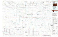
1985 Map of Eureka
USGS Topo · Published 1986About this map
Eureka serves as a central hub in this mid-1980s survey of the borderlands between South Dakota and North Dakota. The landscape is defined by an extensive network of conservation areas, including numerous tracts of the National Waterfowl Production Area and several state-managed game grounds like the Neuharth State Game Production Area. This pattern of land use reflects the region's position within the Prairie Pothole Region, where countless small lakes such as Schumacher Lake and Wolf Lake provide critical habitat. Transportation and commerce are tied to the rail lines of the Burlington Northern and Soo Line, which connect smaller settlements like Hosmer, Zeeland, and Artas. The map also captures specialized communities and local infrastructure, from the Plainview Colony to the Eureka Municipal Airport, illustrating the mixture of traditional agrarian life and modern utility in McPherson and Campbell counties.
Find a feature on this map
63 named features on this map. Tap any name to fly to it.
Don’t see what you’re looking for? This feature index may not catch every label — zoom into the map to look around manually.
Map Details
Editions of this 1985 Eureka Map
3 editions found
Other maps of this area

1896 · Edgeley
USGS Topo · 1:125,000

1899 · Ellendale
USGS Topo · 1:125,000

1899 · Northville
USGS Topo · 1:125,000

1925 · Edgeley
USGS Topo · 1:125,000

1953 · Jamestown
USGS Topo · 1:250,000

1953 · McIntosh
USGS Topo · 1:250,000

1954 · Aberdeen
USGS Topo · 1:250,000

1954 · Bismarck
USGS Topo · 1:250,000

1956 · Aberdeen
USGS Topo · 1:250,000

1956 · Jamestown
USGS Topo · 1:250,000