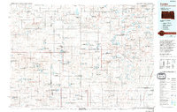
1985 Map of Eureka
USGS Topo · Published 1994About this map
The agricultural landscape of the Missouri Plateau along the North Dakota and South Dakota border is defined here by an intricate network of wetlands and small prairie towns. Eureka sits as a central hub, surrounded by dozens of protected waterfowl areas including the Neuharth State Game Production Area and the Rosenthal State Game Production Area. The transportation infrastructure is anchored by the Soo Line railroad, which connects several smaller elevators and settlements such as Artas, Madra, and Hillsview.
Find a feature on this map
67 named features on this map. Tap any name to fly to it.
Don’t see what you’re looking for? This feature index may not catch every label — zoom into the map to look around manually.
Map Details
Editions of this 1985 Eureka Map
3 editions found
Other maps of this area

1896 · Edgeley
USGS Topo · 1:125,000

1899 · Ellendale
USGS Topo · 1:125,000

1899 · Northville
USGS Topo · 1:125,000

1925 · Edgeley
USGS Topo · 1:125,000

1953 · Jamestown
USGS Topo · 1:250,000

1953 · McIntosh
USGS Topo · 1:250,000

1954 · Aberdeen
USGS Topo · 1:250,000

1954 · Bismarck
USGS Topo · 1:250,000

1956 · Aberdeen
USGS Topo · 1:250,000

1956 · Jamestown
USGS Topo · 1:250,000