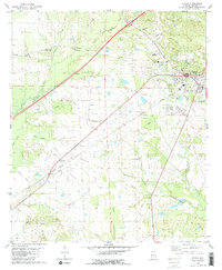
1980 Map of Eutaw
USGS Topo · Published 1980About this map
Eutaw serves as the focal point of this Greene County landscape, situated where the Southern railroad line meets a network of local roads and waterways. The town's layout includes civic and educational landmarks such as Warrior Academy and a Middle School, while the surrounding rural areas are defined by a dense concentration of community churches and family-named cemeteries. Features like Pippen Lawn Cem and Pippen Pace Cem offer significant genealogical value, anchoring the geography to specific local families.
Find a feature on this map
29 named features on this map. Tap any name to fly to it.
Don’t see what you’re looking for? This feature index may not catch every label — zoom into the map to look around manually.
Map Details
Editions of this 1980 Eutaw Map
2 editions found
Other maps of this area

1927 · Eutaw
USGS Topo · 1:48,000

1929 · Epes
USGS Topo · 1:48,000

1931 · Eutaw
USGS Topo · 1:62,500

1932 · Epes
USGS Topo · 1:62,500

1947 · Mason Bend
USGS Topo · 1:24,000

1947 · Forkland
USGS Topo · 1:24,000

1948 · Mason Bend
USGS Topo · 1:24,000

1949 · Forkland
USGS Topo · 1:24,000

1953 · Montgomery
USGS Topo · 1:250,000

1953 · Meridian
USGS Topo · 1:250,000