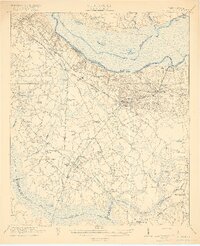
1921 Map of Eutawville
USGS Topo · Published 1921About this map
The Santee River defines the northern reaches of this lowcountry landscape, recorded just before the massive hydroelectric projects of the mid-20th century transformed the basin. Centered on the town of Eutawville, the area is steeped in colonial and revolutionary history, most notably marked by the Eutaw Springs Battle Monument near the riverbank. This era shows a well-established network of rural institutions, including dozens of country churches like Springfield Church and Liveoak Church, alongside numerous segregated local schoolhouses such as Camden Road School and Water Grove School. Transportation is dominated by the Atlantic Coast Line and the specialized Lumber Railroad, which supported the region’s timber economy. To the south, the terrain descends into the dense drainage of Four Hole Swamp and Dean Swamp, revealing a landscape of bays and creek bottoms including Toney Bay and Gibson Bay.
Find a feature on this map
65 named features on this map. Tap any name to fly to it.
Don’t see what you’re looking for? This feature index may not catch every label — zoom into the map to look around manually.
Map Details
Editions of this 1921 Eutawville Map
3 editions found

Other maps of this area

1919 · Summerville
USGS Topo · 1:48,000

1919 · Ridgeville
USGS Topo · 1:48,000

1920 · Eutawville
USGS Topo · 1:48,000

1920 · Chicora
USGS Topo · 1:48,000

1920 · Bowman
USGS Topo · 1:48,000

1920 · Manning
USGS Topo · 1:48,000

1920 · Ridgeville
USGS Topo · 1:62,500

1920 · St. George
USGS Topo · 1:48,000

1920 · Summerville
USGS Topo · 1:62,500

1921 · Chicora
USGS Topo · 1:62,500