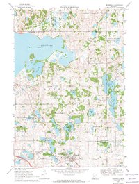
1969 Map of Evansville
USGS Topo · Published 1971About this map
Lake Christina dominates this landscape on the border of Otter Tail and Douglas counties, a region defined by its dense concentration of glacial lakes and extensive conservation lands. In the late 1960s, the village of Evansville served as the local hub, situated at the junction of the Burlington Northern railroad and an Old Railroad Grade that speaks to the area's evolving transportation network. The rural character of the region is grounded by community landmarks such as Christina Lake Ch and Christina Lake Cem, located north of the small settlement of Melby. Extensive public lands, including the Eagle Lake State Wildlife Management Area and Thornberg State Wildlife Management Area, illustrate a significant commitment to preserving the waterfowl habitat and prairie potholes surrounding Eagle Lake and Leaf Mountain.
Find a feature on this map
32 named features on this map. Tap any name to fly to it.
Don’t see what you’re looking for? This feature index may not catch every label — zoom into the map to look around manually.
Map Details
Editions of this 1969 Evansville Map
This is the sole edition of this map. No revisions or reprints were ever made.
Other maps of this area

1911 · Barrett
USGS Topo · 1:62,500

1913 · Ashby
USGS Topo · 1:62,500

1953 · Brainerd
USGS Topo · 1:250,000

1953 · Saint Cloud
USGS Topo · 1:250,000

1957 · Brainerd
USGS Topo · 1:250,000

1957 · Saint Cloud
USGS Topo · 1:250,000

1958 · Saint Cloud
USGS Topo · 1:250,000

1958 · Brainerd
USGS Topo · 1:250,000

1965 · Brainerd
USGS Topo · 1:250,000

1966 · Brandon
USGS Topo · 1:24,000