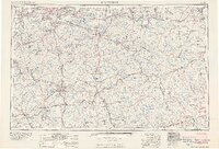
1961 Map of Evansville
USGS Topo · Published 1961About this map
The Ohio River valley serves as the central artery of this mid-century survey, anchoring major urban centers like Evansville, Indiana, and Owensboro, Kentucky. The landscape is defined by the complex drainage of the Green River, Pond River, and Rough River, supporting a region heavily invested in extraction and agriculture, as evidenced by numerous coal mines and oil wells scattered throughout the quadrangle. The map captures a period of significant military and institutional presence, showing the Camp Breckinridge Military Reservation and the sprawling Hoosier National Forest.
Find a feature on this map
72 named features on this map. Tap any name to fly to it.
Don’t see what you’re looking for? This feature index may not catch every label — zoom into the map to look around manually.
Map Details
Editions of this 1961 Evansville Map
2 editions found
Other maps of this area

1900 · St Meinrad
USGS Topo · 1:62,500

1900 · De Gonia Springs
USGS Topo · 1:62,500

1901 · Owensboro
USGS Topo · 1:62,500

1901 · Haubstadt
USGS Topo · 1:62,500

1902 · Ditney
USGS Topo · 1:125,000

1902 · Degonia Springs
USGS Topo · 1:62,500

1902 · Boonville
USGS Topo · 1:62,500

1903 · St. Meinrad
USGS Topo · 1:62,500

1903 · Haubstadt
USGS Topo · 1:62,500

1903 · New Harmony
USGS Topo · 1:62,500