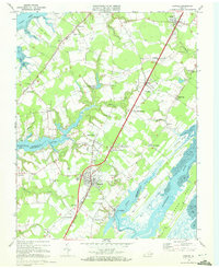
1968 Map of Exmore
USGS Topo · Published 1972About this map
The Penn Central corridor defines the geography of the Eastern Shore in this survey, anchoring a string of small agricultural and commercial hubs from Keller and Painter down through Exmore. This central rail spine provided the vital link for the region's truck farming economy, supported by the Virginia Truck Experimental Station located near Middlesex. While the inland settlements focus on the railroad, the landscape is deeply etched by tidal waterways like Nandua Creek and the Machipongo River, which create a complex network of necks and coves.
Find a feature on this map
61 named features on this map. Tap any name to fly to it.
Don’t see what you’re looking for? This feature index may not catch every label — zoom into the map to look around manually.
Map Details
Editions of this 1968 Exmore Map
4 editions found
Other maps of this area

1931 · Accomac
USGS Topo · 1:48,000

1935 · Accomac
USGS Topo · 1:62,500

1941 · Broadwater
USGS Topo · 1:62,500

1942 · Nandua Creek
USGS Topo · 1:24,000

1942 · Little Machipongo Inlet
USGS Topo · 1:24,000

1942 · Nassawadox
USGS Topo · 1:24,000

1943 · Nassawadox
USGS Topo · 1:31,680

1943 · Jamesville
USGS Topo · 1:31,680

1943 · Pungoteague
USGS Topo · 1:31,680

1943 · Franktown
USGS Topo · 1:31,680