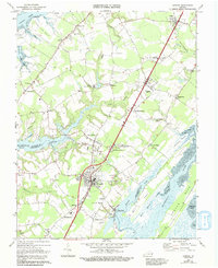
1968 Map of Exmore
USGS Topo · Published 1993About this map
The Eastern Shore peninsula of Virginia is defined here by the crossing of the Pennsylvania railroad and the intricate tidal waters of the Chesapeake Bay and the Atlantic. Centered on the town of Exmore, the landscape reveals a dense network of farming communities and maritime outposts. At Willis Wharf and Oakland Park, the land gives way to the vast Machipongo River and Machipongo Swamp, showing the historical reliance on these waterways for transport and trade. Inland, the Virginia Truck Experimental Station points to the region's agricultural heritage, while numerous small settlements like Painter, Belle Haven, and Craddockville are linked by a grid of rural roads and the rail line. The map captures a moment of transition where established village centers, such as Hadlock and Mappsburg, remained the focal points of local life before later modern development altered the rural character of Northampton and Accomack counties.
Find a feature on this map
65 named features on this map. Tap any name to fly to it.
Don’t see what you’re looking for? This feature index may not catch every label — zoom into the map to look around manually.
Map Details
Editions of this 1968 Exmore Map
4 editions found
Other maps of this area

1931 · Accomac
USGS Topo · 1:48,000

1935 · Accomac
USGS Topo · 1:62,500

1941 · Broadwater
USGS Topo · 1:62,500

1942 · Nandua Creek
USGS Topo · 1:24,000

1942 · Little Machipongo Inlet
USGS Topo · 1:24,000

1942 · Nassawadox
USGS Topo · 1:24,000

1943 · Nassawadox
USGS Topo · 1:31,680

1943 · Jamesville
USGS Topo · 1:31,680

1943 · Pungoteague
USGS Topo · 1:31,680

1943 · Franktown
USGS Topo · 1:31,680