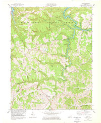
1978 Map of Ezel
USGS Topo · Published 1978About this map
Ezel serves as a primary settlement hub within the undulating terrain of the Daniel Boone National Forest on this 1978 revision. The map highlights a network of small upland communities and family-named landmarks, such as Artville, Korea, and Ebon, connected by a complex system of ridge roads and valley trails. Along the Licking River, the influence of the Cave Run Lake project is evident in the altered water levels and the presence of a boat ramp and local quarries. Genealogists will find an exceptional concentration of family burial grounds, including the Cox Cem, Johnson Cem, and Whitaker Cem, which are scattered throughout the deep hollows. The rural character is further defined by landmarks like the Meetinghouse Branch Ch and a radio tower, illustrating the mixture of traditional settlement patterns and modern infrastructure in Menifee and Morgan Counties.
Find a feature on this map
71 named features on this map. Tap any name to fly to it.
Don’t see what you’re looking for? This feature index may not catch every label — zoom into the map to look around manually.
Map Details
Editions of this 1978 Ezel Map
2 editions found
Other maps of this area

1889 · Salyersville
USGS Topo · 1:125,000

1891 · Salyersville
USGS Topo · 1:125,000

1892 · Beattyville
USGS Topo · 1:125,000

1899 · Salyersville
USGS Topo · 1:125,000

1929 · Morehead
USGS Topo · 1:48,000

1929 · Salt Lick
USGS Topo · 1:62,500

1934 · Salt Lick
USGS Topo · 1:62,500

1935 · Morehead
USGS Topo · 1:62,500

1951 · Cannel City
USGS Topo · 1:24,000

1951 · Ezel
USGS Topo · 1:24,000