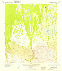
1952 Map of Fairbanks A-1
USGS Topo · Published 1952About this map
The drainage of Dry Creek defines the northern interior landscape of this region as it appeared in the early 1950s, revealing a terrain transitioning from alluvial plains into the high ridges of the Alaska Range. Surveyors identified several prominent vertical control points during this period, including VABM Spirk 1277 to the northeast and the significantly higher VABM Slide 3609 situated in the southern mountainous belt. To the south, the winding course of Slide Creek cuts through steep elevation contours, illustrating the complex hydrology of the Tanana River valley foothills. This 1952 edition reflects the state of topographic mapping just after the post-war aerial surveys of 1949, capturing the natural state of the Alaskan interior before modern development or road networks altered these remote watercourses.
Find a feature on this map
4 named features on this map. Tap any name to fly to it.
Don’t see what you’re looking for? This feature index may not catch every label — zoom into the map to look around manually.
Map Details
Editions of this 1952 Fairbanks A-1 Map
2 editions found
Other maps of this area

1949 · Big Delta B-6
USGS Topo · 1:63,360

1949 · Big Delta A-6
USGS Topo · 1:63,360

1949 · Fairbanks A-2
USGS Topo · 1:63,360

1949 · Fairbanks A-1
USGS Topo · 1:63,360

1949 · Healy D-1
USGS Topo · 1:63,360

1950 · Fairbanks
USGS Topo · 1:250,000

1950 · Mount Hayes
USGS Topo · 1:250,000

1950 · Big Delta
USGS Topo · 1:250,000

1950 · Mount Hayes D-6
USGS Topo · 1:63,360

1950 · Fairbanks B-2
USGS Topo · 1:63,360