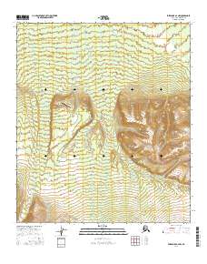
2016 Map of Fairbanks A-2 NW
USGS Topo · Published 2016About this map
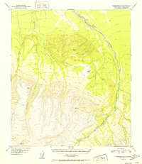
Gold King Creek Airport serves as a remote point of access in this high-elevation interior landscape within the Japan Hills. The terrain is defined by the significant drainage systems of Gold King Cr to the west and Bonnifield Cr running through the center, both carving deep paths through the high country. A prominent geological formation known as The Gap sits between these drainages, marking a natural passage through the elevated ridges. This map captures a wilderness area of the Alaska-Denali Borough where infrastructure is limited to specialized aviation and basic township boundaries such as t8s r2w and t9s r1w, illustrating the intersection of modern topography and a largely undeveloped Alaskan interior.
Find a feature on this map
9 named features on this map. Tap any name to fly to it.
Don’t see what you’re looking for? This feature index may not catch every label — zoom into the map to look around manually.
Map Details
Editions of this 2016 Fairbanks A-2 NW Map
This is the sole edition of this map. No revisions or reprints were ever made.
Other maps of this area

1949 · Fairbanks B-3
USGS Topo · 1:63,360

1949 · Fairbanks A-2
USGS Topo · 1:63,360

1950 · Fairbanks
USGS Topo · 1:250,000

1950 · Fairbanks A-3
USGS Topo · 1:63,360

1950 · Fairbanks B-2
USGS Topo · 1:63,360
1951 · Fairbanks B-2
USGS Topo · 1:63,360

1951 · Fairbanks
USGS Topo · 1:250,000
1952 · Fairbanks A-3
USGS Topo · 1:63,360
1952 · Fairbanks B-3
USGS Topo · 1:63,360
1952 · Fairbanks A-2
USGS Topo · 1:63,360