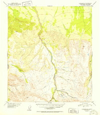
1952 Map of Fairbanks A-3
USGS Topo · Published 1952About this map
Tatlanika Creek serves as the central drainage for this interior Alaskan territory, flowing through a landscape defined by industrial and transportation routes used during the early 1950s. The map illustrates a northern frontier economy where mobility relied on a primitive Sled Road and specialized infrastructure like the Grubstake Airstrip. Evidence of resource extraction is clear near the southern reaches of the creek, where a Placer Mine sits at the confluence of several tributaries, including Grubstake Creek and Roosevelt Creek. Isolated structures, such as a lone Cabin on the banks of Gold King Creek, suggest the sparse, seasonal habitation typical of this era. The drainage patterns of Boulder Creek and Moose Creek further detail the complex watershed that directed prospectors and surveyors through these high-elevation valleys.
Find a feature on this map
19 named features on this map. Tap any name to fly to it.
Don’t see what you’re looking for? This feature index may not catch every label — zoom into the map to look around manually.
Map Details
Editions of this 1952 Fairbanks A-3 Map
2 editions found
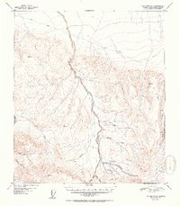
Other maps of this area

1949 · Fairbanks B-4
USGS Topo · 1:63,360

1949 · Fairbanks B-3
USGS Topo · 1:63,360

1949 · Fairbanks A-2
USGS Topo · 1:63,360

1950 · Fairbanks
USGS Topo · 1:250,000

1950 · Healy D-4
USGS Topo · 1:63,360

1950 · Fairbanks A-4
USGS Topo · 1:63,360

1950 · Fairbanks A-3
USGS Topo · 1:63,360

1950 · Fairbanks B-2
USGS Topo · 1:63,360

1950 · Healy D-3
USGS Topo · 1:63,360

1951 · Healy
USGS Topo · 1:250,000