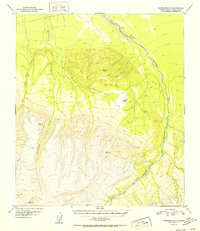
1952 Map of Fairbanks A-2
USGS Topo · Published 1952About this map
Wood River winds through the eastern portion of this territory, serving as a primary geographical marker in a landscape shaped by drainage basins and high elevations. This mid-century survey captures a largely unsettled region defined by its watercourses, including Bonnifield Creek and Gold King Creek, which flow through deep-cut valleys. Evidence of human activity is scarce, noted only by a lone Cabin in the north and a small Coal deposit near the southern boundary, suggesting the very beginnings of resource prospecting or seasonal habitation.
Find a feature on this map
9 named features on this map. Tap any name to fly to it.
Don’t see what you’re looking for? This feature index may not catch every label — zoom into the map to look around manually.
Map Details
Editions of this 1952 Fairbanks A-2 Map
2 editions found
Other maps of this area

1949 · Fairbanks B-3
USGS Topo · 1:63,360

1949 · Fairbanks A-2
USGS Topo · 1:63,360

1949 · Fairbanks A-1
USGS Topo · 1:63,360

1949 · Healy D-1
USGS Topo · 1:63,360

1950 · Fairbanks
USGS Topo · 1:250,000

1950 · Fairbanks A-3
USGS Topo · 1:63,360

1950 · Fairbanks B-2
USGS Topo · 1:63,360

1950 · Fairbanks B-1
USGS Topo · 1:63,360

1950 · Healy D-3
USGS Topo · 1:63,360

1951 · Healy
USGS Topo · 1:250,000