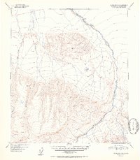
1952 Map of Fairbanks A-2
USGS Topo · Published 1952About this map
Wood River winds through this interior Alaskan landscape, which was documented using aerial photography just after the turn of the mid-century. The terrain is defined by a network of drainage systems, including Bonnifield Creek and Gold King Creek, which flow through the high-elevation country of the Fourth Judicial Division. These watercourses are flanked by prominent surveyed peaks like VABM Wood 4094 and VABM Baker 5144. Evidence of human presence is minimal in this wilderness, represented only by a lone Cabin near the river and the smaller Coal Cr. This map represents the raw state of the Tanana Valley watershed before significant modern development, preserving the original survey points and unchecked elevations as they were first recorded in 1949 and published in the early 1950s.
Find a feature on this map
9 named features on this map. Tap any name to fly to it.
Don’t see what you’re looking for? This feature index may not catch every label — zoom into the map to look around manually.
Map Details
Editions of this 1952 Fairbanks A-2 Map
2 editions found
Other maps of this area

1949 · Fairbanks B-3
USGS Topo · 1:63,360

1949 · Fairbanks A-2
USGS Topo · 1:63,360

1949 · Fairbanks A-1
USGS Topo · 1:63,360

1949 · Healy D-1
USGS Topo · 1:63,360

1950 · Fairbanks
USGS Topo · 1:250,000

1950 · Fairbanks A-3
USGS Topo · 1:63,360

1950 · Fairbanks B-2
USGS Topo · 1:63,360

1950 · Fairbanks B-1
USGS Topo · 1:63,360

1950 · Healy D-3
USGS Topo · 1:63,360

1951 · Healy
USGS Topo · 1:250,000