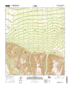
2016 Map of Fairbanks A-3 NE
USGS Topo · Published 2016About this map
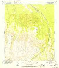
Saint George Cr and Fish Cr trace through this 2016 survey of the Alaska interior, marking the primary drainage paths across a landscape defined by significant elevation changes. The northern half of the sheet shows the terrain leveling out towards the lower reaches of Fish Cr, while the southern portion climbs into high ridges and steep valleys where Saint George Cr originates. This survey preserves the exact Public Land Survey System (PLSS) divisions for townships t8s r4w, t8s r3w, and t8s r2w, which are essential for property researchers and those tracking land claims in the Denali Borough. The map provides a detailed view of the natural watercourse patterns before the intersection of wilderness and modern resource management, reflecting the state of the terrain as it appeared in the mid-2010s.
Find a feature on this map
8 named features on this map. Tap any name to fly to it.
Don’t see what you’re looking for? This feature index may not catch every label — zoom into the map to look around manually.
Map Details
Editions of this 2016 Fairbanks A-3 NE Map
This is the sole edition of this map. No revisions or reprints were ever made.
Other maps of this area

1949 · Fairbanks B-3
USGS Topo · 1:63,360

1949 · Fairbanks A-2
USGS Topo · 1:63,360

1950 · Fairbanks
USGS Topo · 1:250,000

1950 · Fairbanks A-3
USGS Topo · 1:63,360

1950 · Fairbanks B-2
USGS Topo · 1:63,360
1951 · Fairbanks B-2
USGS Topo · 1:63,360

1951 · Fairbanks
USGS Topo · 1:250,000
1952 · Fairbanks A-3
USGS Topo · 1:63,360
1952 · Fairbanks B-3
USGS Topo · 1:63,360
1952 · Fairbanks A-2
USGS Topo · 1:63,360