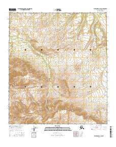
2016 Map of Fairbanks A-3 SW
USGS Topo · Published 2016About this map
Buzzard Creek and Saint-Charles Creek define the high-elevation drainage patterns across this section of the Alaska-Denali Borough. Surveyed in the early 21st century, the landscape is dominated by complex topographical contours that illustrate the steep descent of seasonal and perennial waterways into narrow valleys. The presence of Steep Creek and Boulder Creek indicates a geologically active environment where erosion continues to shape the interior wilderness. This map provides a detailed view of public land survey system divisions, including t9s r5w, t9s r4w, t10s r5w, and t10s r4w, which are essential for understanding land management and administrative boundaries in this undeveloped portion of Alaska.
Find a feature on this map
8 named features on this map. Tap any name to fly to it.
Don’t see what you’re looking for? This feature index may not catch every label — zoom into the map to look around manually.
Map Details
Editions of this 2016 Fairbanks A-3 SW Map
This is the sole edition of this map. No revisions or reprints were ever made.
Other maps of this area

1950 · Fairbanks
USGS Topo · 1:250,000

1950 · Healy D-4
USGS Topo · 1:63,360

1950 · Fairbanks A-4
USGS Topo · 1:63,360

1950 · Fairbanks A-3
USGS Topo · 1:63,360

1950 · Healy D-3
USGS Topo · 1:63,360

1951 · Healy
USGS Topo · 1:250,000

1951 · Fairbanks
USGS Topo · 1:250,000
1952 · Fairbanks A-4
USGS Topo · 1:63,360
1952 · Healy D-3
USGS Topo · 1:63,360
1952 · Fairbanks A-3
USGS Topo · 1:63,360