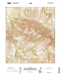
2017 Map of Fairbanks A-4 SE
USGS Topo · Published 2017About this map
The Totatlanika River drainage dominates this section of the Denali Borough, where a network of prospector-named creeks carves through high-elevation terrain. This 2017 survey shows the intricate hydraulic landscape of the interior, featuring water bodies with evocative names like Bonanza Cr, Homestake Cr, and Fourth of July Cr, suggesting a history tied to the search for minerals. The Ferry Eva Moose Creek Road serves as the primary artery through this wilderness, winding toward the Totatlanika River Airport in the southeastern quadrant. Other notable drainages include California Cr, Iron Cr, and Marguerite Cr, which define the rugged topography between the Townships of 9 and 10 South. The map provides a contemporary record of these traditional access routes and named landmarks within the Alaska Range foothills.
Find a feature on this map
25 named features on this map. Tap any name to fly to it.
Don’t see what you’re looking for? This feature index may not catch every label — zoom into the map to look around manually.
Map Details
Editions of this 2017 Fairbanks A-4 SE Map
This is the sole edition of this map. No revisions or reprints were ever made.
Other maps of this area

1950 · Fairbanks
USGS Topo · 1:250,000

1950 · Healy D-4
USGS Topo · 1:63,360

1950 · Fairbanks A-4
USGS Topo · 1:63,360

1950 · Fairbanks A-3
USGS Topo · 1:63,360

1950 · Healy D-3
USGS Topo · 1:63,360

1951 · Healy
USGS Topo · 1:250,000

1951 · Fairbanks
USGS Topo · 1:250,000
1952 · Fairbanks A-4
USGS Topo · 1:63,360
1952 · Healy D-3
USGS Topo · 1:63,360
1952 · Fairbanks A-3
USGS Topo · 1:63,360