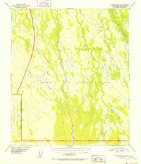
1952 Map of Fairbanks B-4
USGS Topo · Published 1952About this map
Ladd Air Force Base dominates the northern expanse of this 1952 interior Alaska landscape, reflecting the strategic military footprint in the territory during the early Cold War. The terrain is defined by the winding paths of the Totlatlanika River and Tatlanika Creek, which meander through a complex network of wetlands and seasonal watercourses. Large portions of the map are designated as a Bombing and Gunnery Range, underscoring the area's primary use for mid-century aerial training and defense operations. To the southwest, the presence of the Clear Air Force Auxiliary Field (Inactive) highlights the shifting operational needs of the military at this time. Evidence of traditional overland travel is visible in the form of a Sled Road cutting across the northwest, providing a functional link through the wilderness between the drainages of Fish Creek.
Find a feature on this map
9 named features on this map. Tap any name to fly to it.
Don’t see what you’re looking for? This feature index may not catch every label — zoom into the map to look around manually.
Map Details
Editions of this 1952 Fairbanks B-4 Map
2 editions found
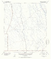
Other maps of this area

1949 · Fairbanks B-5
USGS Topo · 1:63,360

1949 · Fairbanks B-4
USGS Topo · 1:63,360

1949 · Fairbanks B-3
USGS Topo · 1:63,360

1950 · Fairbanks
USGS Topo · 1:250,000

1950 · Fairbanks C-3
USGS Topo · 1:63,360

1950 · Fairbanks C-5
USGS Topo · 1:63,360

1950 · Fairbanks A-5
USGS Topo · 1:63,360

1950 · Fairbanks C-4
USGS Topo · 1:63,360

1950 · Fairbanks A-4
USGS Topo · 1:63,360

1950 · Fairbanks A-3
USGS Topo · 1:63,360