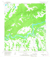
1950 Map of Fairbanks C-4
USGS Topo · Published 1968About this map
The braided channels of the Tanana River dominate this interior landscape, marking a critical corridor for movement across the territory before the mid-20th century expansion of the road system. Along the northwestern edge, The Alaska Railroad cuts through the lowlands near Little Goldstream Creek, following the natural contours of the valley towards the regional hub. This period of development shows the coexistence of established rail infrastructure with seasonal pathways like the Winter Trail and the early Fairbanks Nenana Road. To the southeast, the expansive Air Force Range near Blair Lake and the Wood River indicates the strategic military footprint that grew in the region following the war. The presence of isolated Cabin sites along the riverbanks reflects the enduring reliance on these waterways for subsistence and transport in the subarctic wilderness.
Find a feature on this map
13 named features on this map. Tap any name to fly to it.
Don’t see what you’re looking for? This feature index may not catch every label — zoom into the map to look around manually.
Map Details
Editions of this 1950 Fairbanks C-4 Map
4 editions found
Other maps of this area

1949 · Fairbanks B-5
USGS Topo · 1:63,360

1949 · Fairbanks D-3
USGS Topo · 1:63,360

1949 · Fairbanks D-4
USGS Topo · 1:63,360

1949 · Fairbanks B-4
USGS Topo · 1:63,360

1949 · Fairbanks B-3
USGS Topo · 1:63,360

1950 · Fairbanks
USGS Topo · 1:250,000

1950 · Fairbanks C-3
USGS Topo · 1:63,360

1950 · Fairbanks C-5
USGS Topo · 1:63,360

1950 · Fairbanks C-4
USGS Topo · 1:63,360

1950 · Fairbanks D-5
USGS Topo · 1:63,360