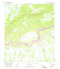
1950 Map of Fairbanks C-4
USGS Topo · Published 1974About this map
The Tanana River dominates this interior Alaska landscape, weaving a braided path through the lowlands south of the Fairbanks North Star Borough line. This 1950 survey, updated with 1972 aerial revisions, documents a critical transportation corridor where The Alaska Railroad and the Fairbanks Nenana Road parallel the northern hills. The map captures the logistical infrastructure of the mid-century, from the isolated Cabin sites along the riverbanks to the expansive Blair Lake Air Force Range and the Winter Trail navigating the terrain. Tributaries like Little Goldstream Creek and the Wood River feed into the Tanana, defining the drainage patterns of this subarctic region before the extensive modern developments of the late 20th century.
Find a feature on this map
12 named features on this map. Tap any name to fly to it.
Don’t see what you’re looking for? This feature index may not catch every label — zoom into the map to look around manually.
Map Details
Editions of this 1950 Fairbanks C-4 Map
4 editions found
Other maps of this area

1949 · Fairbanks B-5
USGS Topo · 1:63,360

1949 · Fairbanks D-3
USGS Topo · 1:63,360

1949 · Fairbanks D-4
USGS Topo · 1:63,360

1949 · Fairbanks B-4
USGS Topo · 1:63,360

1949 · Fairbanks B-3
USGS Topo · 1:63,360

1950 · Fairbanks
USGS Topo · 1:250,000

1950 · Fairbanks C-3
USGS Topo · 1:63,360

1950 · Fairbanks C-5
USGS Topo · 1:63,360

1950 · Fairbanks C-4
USGS Topo · 1:63,360

1950 · Fairbanks D-5
USGS Topo · 1:63,360