
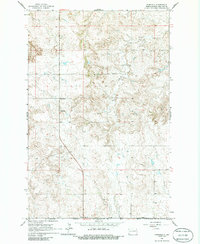
1963 Map of Fairfield
USGS Topo · Published 1964About this map
Fairfield sits as a central node in this Billings County landscape, situated where local roads converge amidst the rolling drainage of the Knife River. This 1960s survey reveals a community-focused rural geography, defined by a network of one-room schoolhouses like the Fairfield Sch, Glade Sch, Hecker Sch, and Joint Sch that served the surrounding farmsteads. The cultural fabric of the township is anchored by the Immaculate Conception Cem, providing a significant point of reference for genealogists and local historians. Economic activity in this era is evidenced by small-scale resource extraction, including a Scoria Pit and multiple Gravel Pits found near the river's winding path. The map effectively documents the transition between the high plains and the broken terrain of the river valley, illustrating the sparsely populated but well-organized settlement pattern of Western North Dakota before modern agricultural consolidation.
Find a feature on this map
14 named features on this map. Tap any name to fly to it.
Don’t see what you’re looking for? This feature index may not catch every label — zoom into the map to look around manually.
Map Details
Editions of this 1963 Fairfield Map
2 editions found
Other maps of this area

1953 · Watford City
USGS Topo · 1:250,000

1957 · Watford City
USGS Topo · 1:250,000

1963 · Fairfield SE
USGS Topo · 1:24,000

1963 · Gorham SE
USGS Topo · 1:24,000

1963 · Gorham
USGS Topo · 1:24,000

1963 · Rattlesnake Butte
USGS Topo · 1:24,000

1963 · Hungry Man Butte
USGS Topo · 1:24,000

1967 · Watford City
USGS Topo · 1:250,000

1974 · Grassy Butte SW
USGS Topo · 1:24,000
1974 · Scairt Woman Draw
USGS Topo · 1:24,000