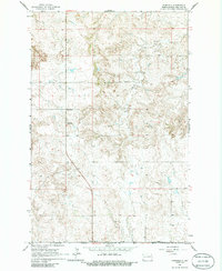
1963 Map of Fairfield
USGS Topo · Published 1986About this map
The settlement of Fairfield serves as the primary hub of this western North Dakota landscape during the early 1960s. The region is characterized by a high density of rural schoolhouses, including Fairfield Sch, Glade Sch, Hecker Sch, and Joint Sch, reflecting the community-oriented distribution of the era's ranching and farming population. Cultural and physical landmarks are concentrated in the northern half of the sheet, where the Knife River winds through the terrain near the Immaculate Conception Cem. Industrial activity is marked by resource extraction sites like the Scoria Pit and various Gravel Pits, which provide insight into the local economy and road-building materials used to navigate this part of Billings County. This survey, based on 1961 aerial photography, captures the structured network of section lines and field fences that organize the vast open country.
Find a feature on this map
11 named features on this map. Tap any name to fly to it.
Don’t see what you’re looking for? This feature index may not catch every label — zoom into the map to look around manually.
Map Details
Editions of this 1963 Fairfield Map
2 editions found
Other maps of this area

1953 · Watford City
USGS Topo · 1:250,000

1957 · Watford City
USGS Topo · 1:250,000

1963 · Fairfield SE
USGS Topo · 1:24,000

1963 · Fairfield
USGS Topo · 1:24,000

1963 · Gorham SE
USGS Topo · 1:24,000

1963 · Gorham
USGS Topo · 1:24,000

1963 · Rattlesnake Butte
USGS Topo · 1:24,000

1963 · Hungry Man Butte
USGS Topo · 1:24,000

1967 · Watford City
USGS Topo · 1:250,000

1974 · Grassy Butte SW
USGS Topo · 1:24,000