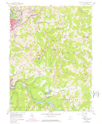
1958 Map of Fairmont East
USGS Topo · Published 1977About this map
The Monongahela River and Tygart Valley River anchor this 1958 survey of northern West Virginia, where the industrial expansion of Fairmont meets a landscape of deeply dissected ridges. The Baltimore and Ohio RR follows the Tygart Valley River through the southern half of the quadrangle, serving small riverfront communities like Hammond and Valley Falls. Rural life during this era is marked by a dense network of mountain schools and churches, including the Quiet Dell Sch and Bunners Ridge Ch, which were central to the scattered townships of Winfield and Union. The terrain is characterized by prominent high ground like Hickman Ridge and Bunners Ridge, where 1976 revisions indicate active Strip Mine operations. This map captures the region before extensive modern development, showing the proximity of early industry to established family farms and small crossroad settlements.
Find a feature on this map
79 named features on this map. Tap any name to fly to it.
Don’t see what you’re looking for? This feature index may not catch every label — zoom into the map to look around manually.
Map Details
Editions of this 1958 Fairmont East Map
3 editions found
Other maps of this area

1886 · St. George
USGS Topo · 1:125,000

1891 · St. George
USGS Topo · 1:125,000

1902 · Fairmont
USGS Topo · 1:62,500

1902 · Morgantown
USGS Topo · 1:62,500

1904 · Blacksville
USGS Topo · 1:62,500

1907 · Thornton
USGS Topo · 1:62,500

1923 · Blacksville
USGS Topo · 1:62,500

1923 · Fairmont
USGS Topo · 1:62,500

1925 · Blacksville
USGS Topo · 1:62,500

1925 · Morgantown
USGS Topo · 1:62,500