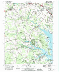
1984 Map of Fairmount
USGS Topo · Published 1992About this map
The coastal headwaters of Rehoboth Bay reveal a landscape defined by tidewater inlets and developing residential pockets in the early 1980s. While established crossroads like Jimtown, Robinsonville, and Hollyville anchor the interior, the map documents the expansion of waterside communities such as Angola by the Bay and Winding Creek Village. The intricate network of "glade" and "prong" waterways, including Pine Water Prong and Stillman Glade, points to the complex drainage of the Delaware coastal plain before heavy modern development. Cultural heritage is well-preserved through numerous historic church and cemetery sites, including the Indian Mission Ch (Cem) and St Georges Chapel (Cem). Industrial and recreational history is also present, marked by scattered Sandpit locations and the Drive-in Theater near Midway. The presence of Goslee Millpond and several named landings like Fisher Landing suggests a long-standing reliance on these small watercourse systems for local transport and early industry.
Find a feature on this map
116 named features on this map. Tap any name to fly to it.
Don’t see what you’re looking for? This feature index may not catch every label — zoom into the map to look around manually.
Map Details
Editions of this 1984 Fairmount Map
3 editions found
Other maps of this area

1917 · Millsboro
USGS Topo · 1:62,500

1918 · Cedar Creek
USGS Topo · 1:62,500

1918 · Rehoboth
USGS Topo · 1:62,500

1918 · Cape Henlopen
USGS Topo · 1:62,500

1919 · Cedar Creek
USGS Topo · 1:62,500

1937 · Cape Henlopen
USGS Topo · 1:62,500

1938 · Cedar Creek
USGS Topo · 1:62,500

1938 · Millsboro
USGS Topo · 1:62,500

1938 · Rehoboth
USGS Topo · 1:62,500

1943 · Fairmount
USGS Topo · 1:24,000
Featured Places
- Angola Crest Mobile Home Park, DE
- Angola Landing, DE
- Cool Spring, DE
- William Ritter Manor, DE
- Mallard Point, DE