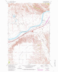
1972 Map of Fallon SW
USGS Topo · Published 1985About this map
The Yellowstone River cuts a wide path through the prairie landscape, defined by the stark elevation change between the river bottom and the massive Broadview Bench to the south. This 1970s survey captures a critical transportation corridor where the Burlington Northern railroad hugs the southern bank of the river, passing through the small community of Fallon and the riverside site of Bluffport. The industrial and agricultural utility of the land is evident in the network of irrigation and water management features, including the Terry Main Canal and the Coal Creek Reservoir with its prominent Spillway. For those researching family history in Prairie Co, the map provides precise locations for the Fallon Cem and scattered infrastructure like the Pumping Sta and various Flowing Wells that supported life on this arid Montana benchland.
Find a feature on this map
21 named features on this map. Tap any name to fly to it.
Don’t see what you’re looking for? This feature index may not catch every label — zoom into the map to look around manually.
Map Details
Editions of this 1972 Fallon SW Map
2 editions found
Other maps of this area

1953 · Miles City
USGS Topo · 1:250,000

1957 · Miles City
USGS Topo · 1:250,000

1958 · Miles City
USGS Topo · 1:250,000

1966 · Fallon
USGS Topo · 1:24,000
1967 · Fallon NE
USGS Topo · 1:24,000

1969 · Zero NE
USGS Topo · 1:24,000

1969 · Flat Top Butte
USGS Topo · 1:24,000

1969 · Flat Top Butte NE
USGS Topo · 1:24,000

1972 · Hendrickson Coulee
USGS Topo · 1:24,000

1972 · Diamond G Creek
USGS Topo · 1:24,000