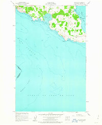
1954 Map of False Bay
USGS Topo · Published 1963About this map
San Juan Island meets the sea at the southern tip of the archipelago in this mid-century survey, defined by the expansive sandy flats of False Bay and the historical grounds of the American Campsite. The landscape reflects the island's strategic and agricultural character, with San Juan Valley Road and Cattle Point Road providing access to the rocky shoreline and fertile interior. Near the southeastern coast, Pickett's Monument stands as a marker of the regional history that shaped this borderland.
Find a feature on this map
19 named features on this map. Tap any name to fly to it.
Don’t see what you’re looking for? This feature index may not catch every label — zoom into the map to look around manually.
Map Details
Editions of this 1954 False Bay Map
Other maps of this area

1943 · Richardson
USGS Topo · 1:62,500

1943 · Orcas Island
USGS Topo · 1:62,500

1954 · Roche Harbor
USGS Topo · 1:24,000

1954 · Friday Harbor
USGS Topo · 1:24,000

1954 · False Bay
USGS Topo · 1:24,000

1957 · Richardson
USGS Topo · 1:62,500

1957 · Orcas Island
USGS Topo · 1:62,500

1957 · Victoria
USGS Topo · 1:250,000

1973 · Shaw Island
USGS Topo · 1:24,000

1975 · Bellingham
USGS Topo · 1:100,000