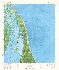
1976 Map of False Cape
USGS Topo · Published 1976About this map
Cape Canaveral Air Force Station and the John F Kennedy Space Center NASA dominate this 1976 orthophotomap, showing the infrastructure of the American space program at the height of the Cold War. The landscape is a complex hybrid of advanced technology and coastal wilderness, where the massive Crawlerway and several launch sites, including Launch Complex 39B and Launch Complex 41, sit adjacent to the protected wetlands of the Merritt Island National Wildlife Refuge.
Find a feature on this map
40 named features on this map. Tap any name to fly to it.
Don’t see what you’re looking for? This feature index may not catch every label — zoom into the map to look around manually.
Map Details
Editions of this 1976 False Cape Map
2 editions found
Other maps of this area

1949 · Orsino
USGS Topo · 1:24,000

1949 · False Cape
USGS Topo · 1:24,000

1949 · Courtenay
USGS Topo · 1:24,000

1949 · Wilson
USGS Topo · 1:24,000

1951 · False Cape
USGS Topo · 1:24,000

1951 · Courtenay
USGS Topo · 1:24,000

1951 · Orsino
USGS Topo · 1:24,000
1951 · Cape Canaveral
USGS Topo · 1:24,000

1952 · Wilson
USGS Topo · 1:24,000

1955 · Orlando
USGS Topo · 1:250,000