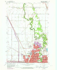
1959 Map of Fargo North
USGS Topo · Published 1973About this map
The Red River of the North winds through this 1950s landscape, serving as the fluid border between Fargo, North Dakota, and Moorhead, Minnesota. The map documents a period of significant educational and institutional concentration, anchored by the North Dakota Agriculture College and numerous parochial institutions like Sacred Heart Academy and St Marys Sch. A clear urban-rural divide is evident as the dense street grids of Fargo give way to the township blocks of Harwood and Reed. Transport infrastructure is dominated by the Burlington Northern railroad, which parallels the river valley. To the north, smaller settlements and rural landmarks like Kragnes and the Oak Mound Sch illustrate the transition into Cass County's agricultural heartland, while the presence of a Radio Range Station and Drive-in Theater reflects the mid-century expansion of the city's periphery.
Find a feature on this map
56 named features on this map. Tap any name to fly to it.
Don’t see what you’re looking for? This feature index may not catch every label — zoom into the map to look around manually.
Map Details
Editions of this 1959 Fargo North Map
4 editions found
Other maps of this area

1895 · Fargo
USGS Topo · 1:125,000

1897 · Fargo
USGS Topo · 1:125,000

1952 · Grand Forks
USGS Topo · 1:250,000

1953 · Fargo
USGS Topo · 1:250,000

1956 · Fargo
USGS Topo · 1:250,000

1956 · Grand Forks
USGS Topo · 1:250,000

1959 · Fargo North
USGS Topo · 1:24,000

1959 · South West Fargo
USGS Topo · 1:24,000

1959 · Fargo South
USGS Topo · 1:24,000

1959 · West Fargo
USGS Topo · 1:24,000