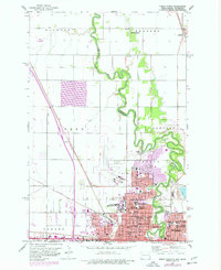
1959 Map of Fargo North
USGS Topo · Published 1977About this map
The Red River of the North winds through this 1959 survey, marking the state boundary between Fargo, North Dakota, and Moorhead, Minnesota. This period captures the region as a significant educational and medical hub, anchored by the North Dakota Agriculture College and institutions like Sacred Heart Academy and St Lukes Hospital. The intricate oxbows of the river define the local geography, creating natural pockets for community spaces such as Oak Grove Park and Island Park.
Find a feature on this map
49 named features on this map. Tap any name to fly to it.
Don’t see what you’re looking for? This feature index may not catch every label — zoom into the map to look around manually.
Map Details
Editions of this 1959 Fargo North Map
4 editions found
Other maps of this area

1895 · Fargo
USGS Topo · 1:125,000

1897 · Fargo
USGS Topo · 1:125,000

1952 · Grand Forks
USGS Topo · 1:250,000

1953 · Fargo
USGS Topo · 1:250,000

1956 · Fargo
USGS Topo · 1:250,000

1956 · Grand Forks
USGS Topo · 1:250,000

1959 · Fargo North
USGS Topo · 1:24,000

1959 · South West Fargo
USGS Topo · 1:24,000

1959 · Fargo South
USGS Topo · 1:24,000

1959 · West Fargo
USGS Topo · 1:24,000