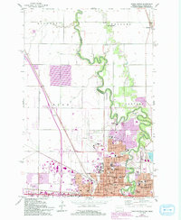
1959 Map of Fargo North
USGS Topo · Published 1993About this map
The Red River of the North winds through the Red River Valley, carving the state line between Fargo, North Dakota, and Moorhead, Minnesota. This mid-century landscape shows a community in transition, with a dense concentration of educational and religious institutions including the Sacred Heart Academy, St Marys Sch, and Oak Grove High Sch clustered near the river core. To the west, Hector Field and the Radio Range Station mark the early development of modern aviation infrastructure, while the surrounding townships of Reed and Harwood maintain their traditional agricultural grids. Genealogists can locate several historic burial grounds such as Fridhem Cem and Riverside Cem. The rail lines of the Great Northern and Northern Pacific underscore the importance of transportation in the growth of these twin cities.
Find a feature on this map
45 named features on this map. Tap any name to fly to it.
Don’t see what you’re looking for? This feature index may not catch every label — zoom into the map to look around manually.
Map Details
Editions of this 1959 Fargo North Map
4 editions found
Other maps of this area

1895 · Fargo
USGS Topo · 1:125,000

1897 · Fargo
USGS Topo · 1:125,000

1952 · Grand Forks
USGS Topo · 1:250,000

1953 · Fargo
USGS Topo · 1:250,000

1956 · Fargo
USGS Topo · 1:250,000

1956 · Grand Forks
USGS Topo · 1:250,000

1959 · Fargo North
USGS Topo · 1:24,000

1959 · South West Fargo
USGS Topo · 1:24,000

1959 · Fargo South
USGS Topo · 1:24,000

1959 · West Fargo
USGS Topo · 1:24,000