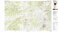
1979 Map of Fayetteville
USGS Topo · Published 1980About this map
Pea Ridge National Military Park and the rugged expanse of the Ozark National Forest anchor this survey of Northwest Arkansas and Eastern Oklahoma. The map reveals a region defined by its diverse water systems, from the sprawling Lake O' the Cherokees and Eucha Lake in the west to the headwaters of the Illinois River and Beaver Lake in the east. The landscape transitions from the dense timber of the Spavinaw Hills State Wildlife Management Area to the growing urban corridor connecting Bentonville, Rogers, and Fayetteville.
Find a feature on this map
94 named features on this map. Tap any name to fly to it.
Don’t see what you’re looking for? This feature index may not catch every label — zoom into the map to look around manually.
Map Details
Editions of this 1979 Fayetteville Map
2 editions found
Other maps of this area

1896 · Pryor
USGS Topo · 1:125,000

1898 · Tahlequah
USGS Topo · 1:125,000

1898 · Winslow
USGS Topo · 1:125,000

1899 · Fayetteville
USGS Topo · 1:125,000

1899 · Siloam Springs
USGS Topo · 1:125,000

1900 · Eureka Springs
USGS Topo · 1:125,000

1901 · Muscogee
USGS Topo · 1:125,000

1901 · Winslow
USGS Topo · 1:125,000

1901 · Vinita
USGS Topo · 1:125,000

1901 · Eureka Springs
USGS Topo · 1:125,000