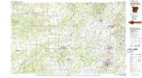
1979 Map of Fayetteville
USGS Topo · Published 1980About this map
The University of Arkansas campus anchors the southern portion of this landscape, reflecting a period of significant growth for Northwest Arkansas. The region is characterized by a dense network of towns like Springdale, Rogers, and Bentonville, which are connected by the Frisco RR. To the north, the Pea Ridge National Military Park preserves a critical Civil War site, while the eastern edge is defined by the expansive waters of Beaver Lake. The terrain shifts from the wooded ridges of the Ozark National Forest and Weddington Mountain to the agricultural expanses of Moseley Prairie. Water resources are a dominant feature, ranging from the Illinois River to specialized landmarks like a Fish Hatchery (Abandoned) and various municipal sewage disposal sites, illustrating the evolving infrastructure of the late 1970s.
Find a feature on this map
117 named features on this map. Tap any name to fly to it.
Don’t see what you’re looking for? This feature index may not catch every label — zoom into the map to look around manually.
Map Details
Editions of this 1979 Fayetteville Map
2 editions found
Other maps of this area

1896 · Pryor
USGS Topo · 1:125,000

1898 · Tahlequah
USGS Topo · 1:125,000

1898 · Winslow
USGS Topo · 1:125,000

1899 · Fayetteville
USGS Topo · 1:125,000

1899 · Siloam Springs
USGS Topo · 1:125,000

1900 · Eureka Springs
USGS Topo · 1:125,000

1901 · Muscogee
USGS Topo · 1:125,000

1901 · Winslow
USGS Topo · 1:125,000

1901 · Vinita
USGS Topo · 1:125,000

1901 · Eureka Springs
USGS Topo · 1:125,000