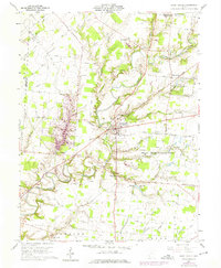
1960 Map of Fayetteville
USGS Topo · Published 1975About this map
Fayetteville and the surrounding townships of Perry and Sterling are defined by the winding course of the East Fork Little Miami River and the Little Miami River. This landscape, situated within the Virginia Military District, reflects a rural settlement pattern where family-named roads like Templin Road and Denman Road connect dispersed small communities. Educational and religious history is centered at Saint Martin, where the Ursuline School For Girls and Ursuline Cem represent significant local landmarks. The map also records the remnants of former transport corridors, specifically the Old Railroad Grade passing through Vera Cruz. Conservation efforts are visible at the Indian Creek Wildlife Area, while various small family and parish burial grounds, including St Patricks Cem and Engle Cem, provide essential data for local genealogists tracing early residents of this Brown County region.
Find a feature on this map
66 named features on this map. Tap any name to fly to it.
Don’t see what you’re looking for? This feature index may not catch every label — zoom into the map to look around manually.
Map Details
Editions of this 1960 Fayetteville Map
2 editions found
Other maps of this area

1907 · Blanchester
USGS Topo · 1:62,500

1914 · Batavia
USGS Topo · 1:48,000

1914 · Morrow
USGS Topo · 1:62,500

1916 · Batavia
USGS Topo · 1:62,500

1916 · Morrow
USGS Topo · 1:62,500

1917 · Sardinia
USGS Topo · 1:62,500

1944 · Sardinia
USGS Topo · 1:62,500

1947 · Columbus
USGS Topo · 1:250,000

1953 · Newtonsville
USGS Topo · 1:24,000
1953 · Williamsburg
USGS Topo · 1:24,000