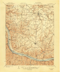
1931 Map of Felicity
USGS Topo · Published 1947About this map
Ohio River steam and rail traffic anchor this 1931 study of Clermont County, where the Cincinnati and Portsmouth electric line and the Georgetown and Cincinnati road converge at the upland hub of Bethel. The landscape is defined by the steep bluffs of the river valley, where historic river towns like Moscow, Chilo, and Neville sit below an intricate network of ridges. Inland, the settlement pattern is marked by an exceptional density of rural education centers, including the Mt Hygiene School, Turkeyfoot School, and Macedonia School. The river itself reveals the engineering of the era with Dam 34 and the active transit of Bondes Ferry connecting the Ohio and Kentucky shores. This map captures a moment when small hamlets like Utopia and Point Pleasant—the birthplace of Ulysses S. Grant—maintained distinct identities tied to the fertile, dissected plateaus of Franklin and Tate townships.
Find a feature on this map
143 named features on this map. Tap any name to fly to it.
Don’t see what you’re looking for? This feature index may not catch every label — zoom into the map to look around manually.
Map Details
Editions of this 1931 Felicity Map
2 editions found

Other maps of this area

1898 · East Cincinnati
USGS Topo · 1:62,500

1914 · East Cincinnati
USGS Topo · 1:62,500

1914 · Batavia
USGS Topo · 1:48,000

1915 · Maysville
USGS Topo · 1:62,500

1916 · Batavia
USGS Topo · 1:62,500

1917 · Sardinia
USGS Topo · 1:62,500

1919 · Maysville
USGS Topo · 1:62,500

1928 · Higginsport
USGS Topo · 1:48,000

1929 · Alexandria
USGS Topo · 1:48,000

1930 · Falmouth
USGS Topo · 1:48,000