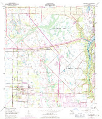
1949 Map of Fellsmere
USGS Topo · Published 1971About this map
Fellsmere serves as the primary hub in this low-lying landscape, where the grid-like development of the town contrasts with the vast, watery expanse of the Fleming Grant. The area is defined by its extensive drainage and aquaculture infrastructure, notably several large Fish Hatchery sites and a prominent telephone line cutting through the terrain. To the east, the waters of the North Prong and South Prong converge into the Sebastian River, a critical waterway for the region's historical drainage and navigation.
Find a feature on this map
14 named features on this map. Tap any name to fly to it.
Don’t see what you’re looking for? This feature index may not catch every label — zoom into the map to look around manually.
Map Details
Editions of this 1949 Fellsmere Map
5 editions found
Other maps of this area

1949 · Fellsmere
USGS Topo · 1:24,000

1949 · Sebastian NW
USGS Topo · 1:24,000

1949 · Vero Beach
USGS Topo · 1:24,000

1949 · Sebastian
USGS Topo · 1:24,000

1949 · Grant
USGS Topo · 1:24,000

1950 · Vero Beach
USGS Topo · 1:24,000

1951 · Sebastian NW
USGS Topo · 1:24,000

1951 · Fellsmere
USGS Topo · 1:24,000

1951 · Grant
USGS Topo · 1:24,000

1951 · Sebastian
USGS Topo · 1:24,000