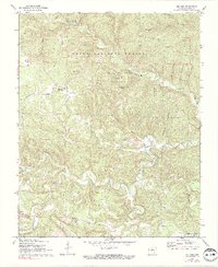
1972 Map of Fiftysix
USGS Topo · Published 1991About this map
Ozark National Forest dominates this section of Stone County, where the topography is defined by the winding course of North Sylamore Creek and its many tributary hollows. The settlement of Fiftysix (Fifty Six) serves as a central point, surrounded by deep-cut terrain including Dave Gunner Hollow and Bud Wallis Hollow. The map reveals a landscape heavily dedicated to public recreation and conservation during the early 1970s, featuring the Gunner Pool Recreation Area and the subterranean wonder of Blanchard Caverns. Local history and genealogy interests are well-represented by rural landmarks such as Shady Grove Ch and the Red Doors Cem near the southern settlement of Newnata. The presence of a Drive-in Theater near Mountain View in the southeast corner provides a distinct cultural marker of the era.
Find a feature on this map
45 named features on this map. Tap any name to fly to it.
Don’t see what you’re looking for? This feature index may not catch every label — zoom into the map to look around manually.
Map Details
Editions of this 1972 Fiftysix Map
3 editions found
Other maps of this area

1890 · Mountain Home
USGS Topo · 1:125,000

1891 · Mountain Home
USGS Topo · 1:125,000

1892 · Mountain View
USGS Topo · 1:125,000

1894 · Mountain View
USGS Topo · 1:125,000

1894 · Mountain Home
USGS Topo · 1:125,000

1945 · Harrison
USGS Topo · 1:250,000

1949 · Harrison
USGS Topo · 1:250,000

1954 · Harrison
USGS Topo · 1:250,000

1956 · Russellville
USGS Topo · 1:250,000

1958 · Harrison
USGS Topo · 1:250,000