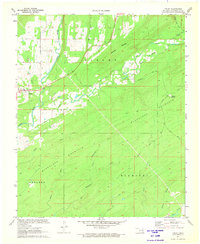
1972 Map of Finley
USGS Topo · Published 1973About this map
Finley stands as the primary settlement in this early 1970s survey, situated along the winding course of Cedar Creek. The landscape is dominated by the ridges of Blackjack Mountain and Kiamichi Mountain, where the terrain's complexity is navigated by historic routes such as the Gunsmoke Trail and the Rattan Tram Trail. These paths suggest the area's history with timber or transit, moving across high points like Roundtop Mountain.
Find a feature on this map
24 named features on this map. Tap any name to fly to it.
Don’t see what you’re looking for? This feature index may not catch every label — zoom into the map to look around manually.
Map Details
Editions of this 1972 Finley Map
This is the sole edition of this map. No revisions or reprints were ever made.
Other maps of this area

1901 · Antlers
USGS Topo · 1:125,000

1901 · Alikchi
USGS Topo · 1:125,000

1912 · Antlers
USGS Topo · 1:125,000

1925 · Antlers
USGS Topo · 1:125,000

1950 · Mcalester
USGS Topo · 1:250,000

1961 · Antlers East
USGS Topo · 1:24,000

1962 · McAlester
USGS Topo · 1:250,000

1965 · McAlester
USGS Topo · 1:250,000

1971 · Spencerville
USGS Topo · 1:24,000
1971 · Rattan
USGS Topo · 1:24,000