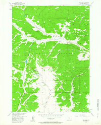
1956 Map of Fish Lake
USGS Topo · Published 1963About this map
The Continental Divide serves as the literal backbone of this 1956 survey, splitting the high country between the Teton National Forest and Shoshone National Forest. High-altitude water bodies like Fish Lake and Trout Creek Lake are tucked into the drainages of Fish Lake Mountain, surrounded by a complex network of pack trails and jeep trails. This landscape is defined by its seasonal grazing and transit history, anchored by the Red Flat Cow Camp along Trout Creek. The map documents a rugged watershed where numerous streams, including Devils Hole Creek, Bullmoose Creek, and the many forks of Warm Spring Creek, emerge from the timbered slopes to carve the topography of Fremont County. It remains a portrait of the American West's high-country wilderness before modern infrastructure reached these forest boundaries.
Find a feature on this map
24 named features on this map. Tap any name to fly to it.
Don’t see what you’re looking for? This feature index may not catch every label — zoom into the map to look around manually.
Map Details
Editions of this 1956 Fish Lake Map
5 editions found

Other maps of this area

1902 · Mt Leidy
USGS Topo · 1:125,000

1905 · Younts Peak
USGS Topo · 1:125,000

1907 · Younts Peak
USGS Topo · 1:125,000

1907 · Gros Ventre
USGS Topo · 1:125,000

1909 · Fremont Peak
USGS Topo · 1:125,000

1910 · Gros Ventre
USGS Topo · 1:125,000

1955 · Driggs
USGS Topo · 1:250,000

1955 · Thermopolis
USGS Topo · 1:250,000

1956 · Esmond Park
USGS Topo · 1:24,000

1956 · Warm Spring Mountain
USGS Topo · 1:24,000