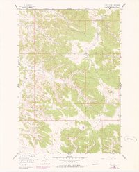
1958 Map of Fisher Butte
USGS Topo · Published 1978About this map
The Northern Cheyenne Indian Reservation landscape is defined by its intricate drainage networks and early industrial activity in the late 1950s. Near the northwest corner, the Lame Deer Strip Mine indicates the region's mineral extraction history, while the surrounding terrain is carved by numerous seasonal and perennial watercourses. Named features such as Soldier Gulch and Broken Jaw Creek reflect a local nomenclature rooted in the physical challenges of the Rosebud County backcountry. The map reveals a land dependent on scattered water sources, documenting several vital points like Crazy Head Spring, White Horse Spring, and Station Spring. These springs and the winding course of Lame Deer Cr provided the essential framework for movement and land use before later developments altered the landscape. This 1978 photorevision also captures the complex topography surrounding the prominent Fisher Butte, illustrating the relationship between the elevated divides and the valleys of Alderson Creek.
Find a feature on this map
28 named features on this map. Tap any name to fly to it.
Don’t see what you’re looking for? This feature index may not catch every label — zoom into the map to look around manually.
Map Details
Editions of this 1958 Fisher Butte Map
3 editions found
Other maps of this area

1954 · Hardin
USGS Topo · 1:250,000

1957 · Hardin
USGS Topo · 1:250,000

1958 · Hardin
USGS Topo · 1:250,000

1958 · Garfield Peak
USGS Topo · 1:24,000

1958 · Jimtown
USGS Topo · 1:24,000

1958 · Fisher Butte
USGS Topo · 1:24,000

1958 · Lame Deer
USGS Topo · 1:24,000

1958 · Badger Peak
USGS Topo · 1:24,000

1958 · Hollowwood Creek
USGS Topo · 1:24,000

1966 · Birney Day School
USGS Topo · 1:24,000