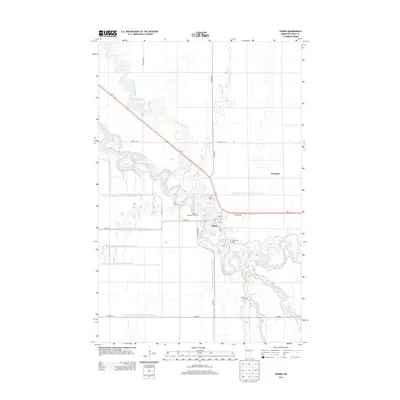
2013 Map of Fisher
USGS Topo · Published 2013About this map
Fisher sits at a major oxbow of the Red Lake River, where the serpentine waterway carves a complex path through the flat agricultural landscape of Polk County. This region is defined by a dense network of drainage engineering, evidenced by numerous named channels such as County Ditch Number One Hundred Seventeen and County Ditch Number One Hundred Thirtyfour. These systems support the vast fields surrounding the settlement of Freeman and the central hub of Fisher itself. Genealogists will find significant value in the distribution of local burial sites, including the Fisher Lutheran Cem, Greenwood Cem, Erickson Cem, and the original Fisher Cem. The map also traces the convergence of infrastructure where Us-2 and Co HWY-15 meet the riparian corridor, illustrating how transportation routes have adapted to the winding river and the expansive Grand Marais Creek drainage basin.
Find a feature on this map
30 named features on this map. Tap any name to fly to it.
Don’t see what you’re looking for? This feature index may not catch every label — zoom into the map to look around manually.
Map Details
Editions of this 2013 Fisher Map
This is the sole edition of this map. No revisions or reprints were ever made.
Other maps of this area

1919 · Eldred
USGS Topo · 1:62,500

1919 · Beltrami
USGS Topo · 1:62,500

1952 · Grand Forks
USGS Topo · 1:250,000

1953 · Crookston
USGS Topo · 1:62,500

1956 · Grand Forks
USGS Topo · 1:250,000
1963 · Mallory
USGS Topo · 1:24,000
1963 · Key West
USGS Topo · 1:24,000

1964 · Girard
USGS Topo · 1:24,000

1964 · Climax NW
USGS Topo · 1:24,000
1964 · Fisher
USGS Topo · 1:24,000