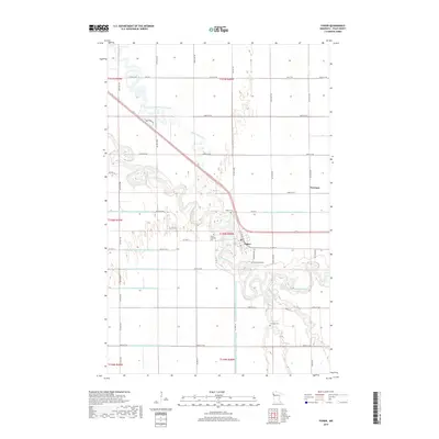
2019 Map of Fisher
USGS Topo · Published 2019About this map
Fisher sits at a prominent bend of the Red Lake River in Polk County, serving as the central hub for this agricultural region of northwestern Minnesota. The landscape is defined by the sinuous meanders of the river and Burnham Cr, set against an extensive network of man-made drainage systems including County Ditch Number One Hundred Seventeen and County Ditch Number One Hundred Sixtythree. These ditches reflect the intensive land management required to sustain farming on the flat glacial plains. Genealogists will find several local landmarks of interest, such as Fisher Lutheran Cem and Erickson Cem, alongside the small settlement of Freeman to the east. The map captures the rectilinear grid of township roads that connects these scattered rural features and watercourses.
Find a feature on this map
56 named features on this map. Tap any name to fly to it.
Don’t see what you’re looking for? This feature index may not catch every label — zoom into the map to look around manually.
Map Details
Editions of this 2019 Fisher Map
This is the sole edition of this map. No revisions or reprints were ever made.
Other maps of this area

1919 · Eldred
USGS Topo · 1:62,500

1919 · Beltrami
USGS Topo · 1:62,500

1952 · Grand Forks
USGS Topo · 1:250,000

1953 · Crookston
USGS Topo · 1:62,500

1956 · Grand Forks
USGS Topo · 1:250,000
1963 · Mallory
USGS Topo · 1:24,000
1963 · Key West
USGS Topo · 1:24,000

1964 · Girard
USGS Topo · 1:24,000

1964 · Climax NW
USGS Topo · 1:24,000
1964 · Fisher
USGS Topo · 1:24,000