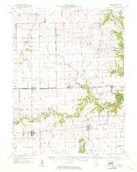
1957 Map of Fithian
USGS Topo · Published 1961About this map
The Salt Fork river winds across this landscape of east-central Illinois, connecting a string of small agricultural and rail communities during the mid-1950s. The region is defined by a dense network of transit, including the Chicago and Eastern Illinois and the New York Central railroads, which served as the lifeblood for towns like Fithian, Muncie, and Oakwood. The presence of Kickapoo State Park in the northeast corner reveals a transition from the grid-based farmland of Champaign and Vermilion counties to a more varied terrain near Glenburn. Genealogists will find a wealth of local landmarks, from rural schools like the Red Oak Sch 1888 to family-named burial grounds such as Stump Cem and Daugherty Cem, many located near the established townships of Pilot and South Homer.
Find a feature on this map
64 named features on this map. Tap any name to fly to it.
Don’t see what you’re looking for? This feature index may not catch every label — zoom into the map to look around manually.
Map Details
Editions of this 1957 Fithian Map
3 editions found
Other maps of this area

1899 · Danville
USGS Topo · 1:62,500

1900 · Danville
USGS Topo · 1:62,500

1906 · Urbana
USGS Topo · 1:62,500

1924 · Paxton
USGS Topo · 1:62,500

1927 · Paxton
USGS Topo · 1:62,500

1931 · Fithian
USGS Topo · 1:48,000

1933 · Hoopeston
USGS Topo · 1:48,000

1936 · Potomac
USGS Topo · 1:62,500

1938 · Hoopeston
USGS Topo · 1:62,500

1943 · Fithian
USGS Topo · 1:62,500