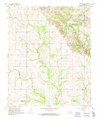
1967 Map of Fittstown
USGS Topo · Published 1991About this map
The West Fittstown Oil Field dominates the northern landscape of this Oklahoma survey, highlighting the energy production that shaped Pontotoc County during the mid-20th century. In the hills to the south, the Blue River and its tributaries carve through the terrain, sustaining small settlements like Franks and the northern reaches of Gibbs. Local history and genealogy are well-represented by rural landmarks such as Sunshine Ch, Franks Cem, and Brown Cem, while the industrial footprint is visible through numerous Quarries and a local Gravel Pit. Notable water features include Byrds Mill Spring and a clearly marked Aqueduct, illustrating the infrastructure required to manage water resources in this part of the state. The map also delineates the Pontotoc and Johnston County line, capturing a rural landscape defined by both its natural hydrology and extractive industry.
Find a feature on this map
24 named features on this map. Tap any name to fly to it.
Don’t see what you’re looking for? This feature index may not catch every label — zoom into the map to look around manually.
Map Details
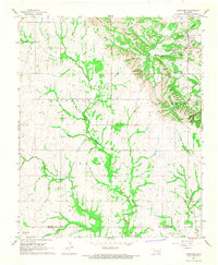
Editions of this 1967 Fittstown Map
2 editions found
Other maps of this area

1901 · Stonewall
USGS Topo · 1:125,000

1901 · Tishomingo
USGS Topo · 1:125,000

1957 · Stonewall
USGS Topo · 1:24,000

1957 · Ardmore
USGS Topo · 1:250,000

1963 · Ardmore
USGS Topo · 1:250,000

1963 · Mill Creek
USGS Topo · 1:24,000
1966 · Harden City
USGS Topo · 1:24,000

1967 · Roff South
USGS Topo · 1:24,000

1967 · Ahloso
USGS Topo · 1:24,000

1967 · Connerville
USGS Topo · 1:24,000